3 hiking suggestions developed for us by Peter Rütten
Preface
The description of these hiking routes was created during my stay on the island for several months, between September 2011 and June 2012, based in Christos Rahes.
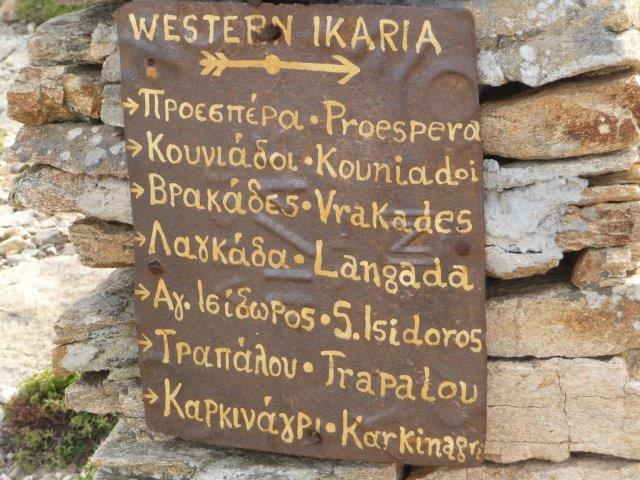
I was extremely pleasantly surprised by the dense and mostly well-marked network of trails. My thanks and recognition therefore go to the Association for Culture and Welfare of Rahes, Icaria around Angelos Calokerinos, to all the activists and helpers who began about ten years ago to make old connecting routes (monopáti) accessible again and who continue to do so for them Ensure preservation and accessibility. In this context, we would also like to point out the card published by this association, which is available in Greek, English and German (translated by Ursula Kastanias) in local stationery stores. It only concerns the Raches/Westikaria area and, in addition to the hand-drawn map sheet, also contains interesting information about Ikaria, but is more suitable for experienced orienteers. The map from the “TERRAIN” map publisher is highly recommended. This map covers the entire island. It not only shows you the complete road network, but also all the gravel roads and dirt roads. Finally a map that correctly shows even small country routes. This way you can easily find your way around. Proceedings/processes excluded!
The present tour descriptions are mostly based on multiple visits and have been corrected and supplemented. Of course, it cannot be ruled out that errors and ambiguities have crept into the route and terrain description. In such cases, I would like to ask users to share their experiences and critical comments with me.
The times noted on the tours assume an average, brisk walking pace. Temperature and path conditions can of course lead to a longer duration. The water level of the streams, which occasionally have to be crossed, can also cause difficulties and delays. In principle, all rivers, including the Chaláres, were passable even in winter. Of course, you had to be prepared to take off your shoes every now and then and get into the water
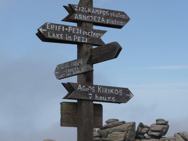
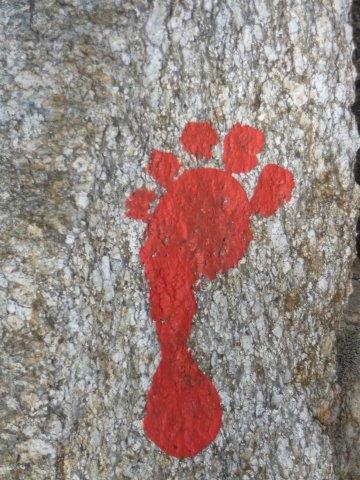
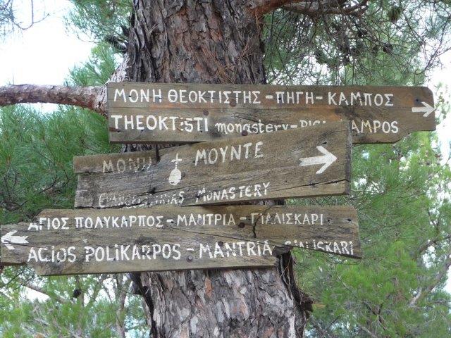
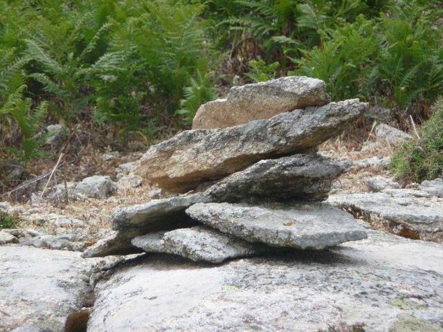
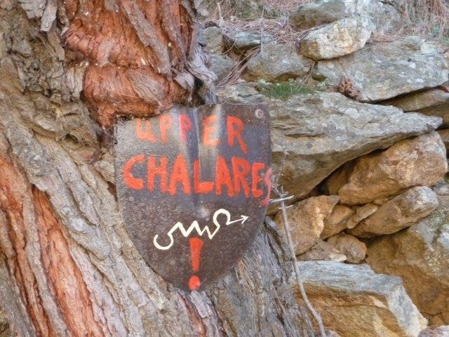
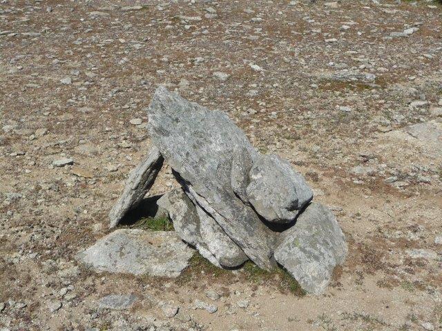
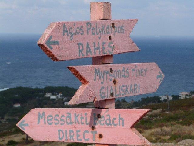
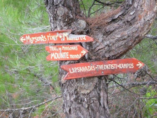
The majority of the paths are old connecting routes, so-called monopáti, on which, until recently, a considerable part of the island’s traffic was carried out on foot and with pack animals. They are evidence of the admirable art of road construction by previous generations, which deserve our respect and which must be preserved as technical monuments. (PS: The photos are examples of the various typical route markings, randomly distributed throughout the text.)
1. Circular hike – Karidiés – Erifí – upper Chaláres Gorge – Profítis Elias – Karidiés
Duration 3.5 – 4 hours
The very varied path is a classic, partly still well-developed monopáti. It is mostly clearly marked and runs for long stretches in wooded areas, making this tour suitable for hot days.
Start about 100 m after the Rahes/Karidiés road fork on the asphalt road to Vracádes or Pézi. In front of a road bridge there is a sign pointing left to “ERIFI 3 hrs.” Following the red markings, you initially cross an inhabited area. At its edge, the path climbs steeply up through the forest on the right and quickly gains height. In principle you keep your distance from the gorge on the left side, from where you can hear the babbling stream. When you reach the first larger block fields (after approx. 35 minutes) the monopáti forks. A mark is missing here. You climb up to the right and soon find yourself confirmed by red dots. A few minutes later you reach a place like a square with a fork in the road. Here you pay attention to stone men and red dots and keep half to the left. The now temporarily wide forest path ends shortly afterwards abruptly at a terraced field that has recently been very roughly dug into the landscape. The area is enclosed by a metal fence and is therefore not accessible. You go around it in a wide left-right arc and see the lost monopáti again in a depression to the left of the upper corner of the field. You can now either follow it to the left through the forest, or after a few meters you can climb up to the right and after 100 meters you will reach a small tarred road, which you follow in a left-hand direction. After about 100 meters you can see the sign “RAHES direct” on a tree on the left.
The alternative route also arrives there. From here a marked path leads left up the slope, further to Erifi (see Tour 2) or to the right, following a marking, to the Chaláres dam. (see also Tour 2). You reach the dam about 1.5 hours after the start.
The further route into the upper Chaláres Gorge is somewhat unclear in the first part due to the destruction caused by the storm in October 2010. At the dam of the reservoir, following the red dots, you descend through scree to an eye-catching concrete canal. Continue on the concrete until you reach a closure sign.
The canal was then torn open by the water masses shooting out of the reservoir overflow opposite, which is why you have to bypass this point on the right above. Then back down to the undestroyed continuation of the canal. The structure ends at a wide path that now leads downward through the forest.
At a red marking, a narrow path branches off to the left. It leads through a dilapidated property with remarkable natural stone architecture. The path now meets the asphalt road leading to Vracádes on the left. Here you don’t follow the misleading marking on the opposite side of the road, but instead go a few meters to the right on the road and then find the correct marking on the left. Further above the Chaláres Gorge, until you reach a fork in the hiking trail a little later: On the left, on a tree, there are several directional signs (“NAS 5 hrs. / CHALARES DAM (Greek) / “KARIDIES, PROFITIS ELIAS”). [The direction “NAS” leads steeply down through the forest and later meets the path leading up from Dipótama at a large signpost. At this junction you could climb up to Profitis Elias. When you reach the asphalt road, follow it to the right and, at the junction with the road coming to the left of Karidiés, keep right again and reach the starting point after another 300 meters. This extends the tour by a good 45 minutes.]
The direction “KARIDIES, PROFITIS ELIAS” is approached on a wide, half-right path leading upwards. You soon come to the road coming from Rahes and Karidiés, follow it to the left for about 1000 meters and you have reached the starting point.
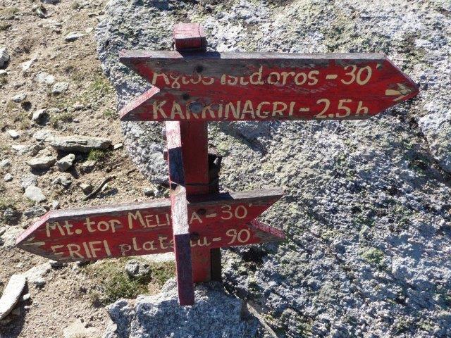
2. Circular hike – Chaláres Dam – Erifí–Mélissa – Agios Isídoros – Chaláres Dam
Duration: 5.5 – 6 hours
Start at Chalares reservoir. On the side of the road opposite the lake, a directional sign (“ERIFI”) points uphill. After a short climb and immediately before reaching a crossing tar road, three right-angled red arrows point to the left. If you follow them you will come to the street mentioned, which you follow to the right for about 300 m until you come to a fork in the path on the left. A signpost (“RAHES direct”) points to the left, but our path is well marked up the slope towards a dry stone wall. [If you want to avoid the road, you can continue straight ahead at the three red arrows, between a collection of beehives with caravan trailers and continue on a slightly marked path through the forest; You pass a dilapidated stone house and shortly afterwards you reach the small street again (opposite the aforementioned signpost).]
You walk through the dry stone wall and, in the rubble fields that follow, you orientate yourself primarily on the stone men erected at short intervals. After about 45 minutes on foot and shortly before you reach the small road again (which is no longer tarred here), you have to be careful when you come to a group of trees next to a stone man: you keep right here through a field of ferns towards a huge collection of rubble. From there, stone men lead back to the street mentioned.
On the opposite side of the road, slightly offset to the right, a connection marker leads up the slope through a field of ferns. After initial orientation problems, the path is soon clearly recognizable through frequently created stone men and red dots. You climb over a hill and follow the always clearly marked path downwards. After about 40 minutes you reach a road near a holm oak grove and a signpost that shows four destinations: Straight ahead – i.e. crossing the path – to the “RYAKAS WATERFALL”; in the opposite direction to the “CHALARES DAM”; to the left to the “AMMOUDIA PLANE”; and to the right “MELISSA / AG. ISÍDOROS”.
Follow the latter direction for a few hundred meters until the monopáti branches off to the left (tape marking on a tree, later red dots and stone men) and bypasses a large area enclosed by stone walls. After about 10 minutes you reach the sand track again and follow it steeply uphill. Shortly after reaching the hill, the slope crosses a holm oak forest and ends here. As soon as you enter this wood, look out for a marker on the right (pale red arrows on large rocks and stones in a fork of a branch). You follow the easily recognizable narrow path that leads to the right through the woods (very rarely marked with red dots), passes a dilapidated stone building with a goat pen and about 200 meters later cross the dry stream bed running on the left, where on the opposite side there is a Steinmann shows the further route. Half-right upwards through stone and scree slopes, always oriented towards cairns, rarely towards red dots. When you reach the first hill, keep half left in a southwesterly direction. The stone men lead through a dry stream bed and then up to a collection of large stone blocks.
From here and further along, the markings through conspicuous piles of stones or individual, exposed stones can only be recognized with great attention. Since the area is open and easy to walk on, you will always find waymarks. An important reference point is the highest point on the terrain, Mélissa (1033 m), on the left side. Quite close to this peak, you gradually descend in a southwesterly, later westerly direction using sparse stone markings (sometimes even a weathered red dot). You follow a stream cut for a few hundred meters and finally reach the end of a road at a goat gate. Follow this downwards until you reach a signpost (“AGIOS ISÍDOROS”). Here you can decide whether you want to reach your destination on the path that turns left (shorter and well marked) or on the path you have already taken. In the latter case, follow the road for about 400 meters until it opens into a wide sandy track. Turn left here and left again after about 100 meters. Clearly recognizable paths or a road now lead over a short distance down to the chapel (drinking water and toilets). The way back to the starting point takes just under an hour on the sandy track past Pézi. Maybe you can also find a ride.

3. Circular hike – Frandáto – Agios Dimitrios – Frandáto
Duration: Until Ag. Dimitrios 3.5 hours
The tour begins in Frandáto. You park in the center of the town and leave it on the initially asphalted road towards Dháfni etc. Shortly after an old watermill on the right of the road, a small road turns off to the right, 15 minutes after the start. A plaque refers to Manganítis and the Rándi Forest. Follow this little road slightly uphill and soon through an old pine forest. In a right-hand bend (15 minutes after the junction) you leave the street and go straight ahead through a metal gate. This leads to an old monopáti, artfully adapted to the terrain and often fortified with curbs, which is almost always clearly visible, although only very rarely marked by stone men. At the beginning you have to be careful not to go too far to the left on the edge of a gorge, but rather on the upper right slope. After about 45 minutes (counting from the junction) the monopáti ends at a concrete stream bed. Here you go straight ahead for a few meters and then turn slightly uphill to the right through an opening in the fence. A sandy track begins there, which you follow in a westerly direction. After 200 meters she comes to another street.
Here you turn left and in about 20 minutes you reach the hill between the Megalofos region and the Papoutsokrýftis ridge. There is a fork in the path at a conspicuous block formation where the sandy path curves to the left. To the right, stone men lead upwards into the regions of Megalofos and Zyzókampos. Straight ahead you reach the demolition point to the south coast after a few meters. There is a great view down to Manganítis, which you can also get to from here on a monopáti (has not been checked).
Follow the left-hand bend of the sand track and then go straight ahead for about 100 meters. Here the slope bends to the right and ends after another 80 meters near a clearly visible stone man. From there you descend to the left to a sandy stream bed and on the opposite side of the slope you can see another stone man at some height, which indicates the monopáti. You now climb, guided by other stone men, on the northern slope of Papoutsokrýftis to a saddle, just below the mountain peak on the right. The path initially stays just below the ridge, but then descends increasingly downwards in an easterly direction. With the help of the cairns, which are usually clearly visible, you reach the upper foothills of the Randi forest, which you cross on a clearly visible monopáti, which from here on out is marked not only by cairns but also by red-green markings.
You pass a crossroads marked by a conspicuous red-green circle marking. The right branch leads down to the south coast to Manganítis. We continue straight ahead through the forest, always staying at the upper edge. This is later followed by open terrain with large block fields, through which stone men lead safely. On the right you will soon see the asphalt road leading down to Manganítis (right) or Plaghiá, south of the top of the pass near the chapel of Agios Dimítrios. The latter can be seen shortly before entering a small forest gorge, which leads directly down to the asphalt road opposite the chapel. From here it would be advisable to hitchhike in a northerly direction down to Steli (5 km) and from there walk again via Petropoúli on a sandy road back to Frandáto (6 km).